Besides May being a prime geocaching month weather-wise, there's also a couple of key events worth putting on your calendars if you haven't already.
First, on May 10th, is the World Wide Flash Mob III Event, which will take place at 10:00 A.M. pacific standard time all over the globe, and will only last for 15 minutes (so don't be late). More information can be found in this previous post. Look for an event near you.
Then, the mother of all mega-events, GeoWoodstock VI is scheduled for May 24th in Wheatland, California. It's so big, it even has its own website.
This should make for one gigantic month of geocaching. Hopefully, I'll get to see/meet many of you at one, or both, of these major events.
Cache On!
April 26, 2008

April 18, 2008
Knowledge Through Geocaching
This recent article in the San Francisco Chronicle reminds readers that this is the 50th anniversary of the running of the last passenger train across the San Francisco-Oakland Bay Bridge. The column gives a brief account of the history of that service, known as the Key System (named after the layout of of rail lines, which resembled a gigantic key). I , unfortunately, was born too late to ride these electric trains; but I do remember how my parents and grandparents used to speak fondly of it.
Reading this article reminded me of one of my very first geocache finds: Eastport (GCD0CD). Inside the cache container was some information about the old railroad line that used to run through the very spot where the cache was hidden, along with some historic photos. The cache owner also included a link to his web site, Bay Area Rails: Then and Now, which contains a plethora of fascinating information, historic photos and maps, and old newspaper clippings on the subject. Here's a photo showing what the area looked like in 1957 (Photo courtesy of Donald Duke):

Even though I grew up in the Bay Area, I had never learned as much about its rail history as I did from finding that cache. Now every time I drive or ride by this spot, I try to imagine what it must have been like here nearly 100 years ago when trains used to rumble back and forth through this canyon.
So even though I never had an opportunity to ride the Bay Area's early railroad service, I was at least able to gain a much better appreciation of what it was like here during that time. Whether you're a long-time resident or a first-time visitor to an area, it's amazing how much history you can learn about a place from doing a little geocaching. Just another of the many benefits of our little hobby.
Keep On Cachin'
Reading this article reminded me of one of my very first geocache finds: Eastport (GCD0CD). Inside the cache container was some information about the old railroad line that used to run through the very spot where the cache was hidden, along with some historic photos. The cache owner also included a link to his web site, Bay Area Rails: Then and Now, which contains a plethora of fascinating information, historic photos and maps, and old newspaper clippings on the subject. Here's a photo showing what the area looked like in 1957 (Photo courtesy of Donald Duke):

Even though I grew up in the Bay Area, I had never learned as much about its rail history as I did from finding that cache. Now every time I drive or ride by this spot, I try to imagine what it must have been like here nearly 100 years ago when trains used to rumble back and forth through this canyon.
So even though I never had an opportunity to ride the Bay Area's early railroad service, I was at least able to gain a much better appreciation of what it was like here during that time. Whether you're a long-time resident or a first-time visitor to an area, it's amazing how much history you can learn about a place from doing a little geocaching. Just another of the many benefits of our little hobby.
Keep On Cachin'
April 12, 2008
Syncing Photos With Your GPS Tracks
A couple of weeks ago we discussed how to display your GPS tracks in Google Earth. But wouldn't it be nice if we could also save the locations of the exact spots where we happened to have taken photographs when we were out geocaching? Well, guess what, you can. Actually, there are several ways to do this:

You can see the thumbnail images it placed at the exact locations I took these photos along this bike ride/caching adventure. In Google Earth, you can click on the thumbnails to bring up larger versions of the images.
The program also lets you create a Google Maps file to publish your pictures and tracks on the web. Here's the same track and image data from above in Google Maps. Feel free to zoom in and click on the photo icons to see the thumbnails. Then click on the thumbnails for larger versions of the images.
Needless to say, I am really impressed with GPicSync, and can't wait to use it again. And the best part... it's free!
Keep on cachin'!
- You can create Placemarks in Google Earth or in Google Maps' My Maps, and add your own images to those Placemarks. You just have to know where you were when you took the picture.
- You can use online image hosting sites like flickr and Picasa that allow you to geotag your uploaded images with coordinate data. Again, you still need to estimate the location from which you took the picture to create the geotag.
- Or, you can use my new favorite program, GPicSync, which automates the entire process for you.

You can see the thumbnail images it placed at the exact locations I took these photos along this bike ride/caching adventure. In Google Earth, you can click on the thumbnails to bring up larger versions of the images.
The program also lets you create a Google Maps file to publish your pictures and tracks on the web. Here's the same track and image data from above in Google Maps. Feel free to zoom in and click on the photo icons to see the thumbnails. Then click on the thumbnails for larger versions of the images.
Needless to say, I am really impressed with GPicSync, and can't wait to use it again. And the best part... it's free!
Keep on cachin'!
April 3, 2008
Google Maps, Now With Contour Lines
If you're a Topographic Map fanatic like me, then you'll appreciate this. Google Maps, which fairly recently added a terrain view option to go with the standard map and satellite views, has just added contour lines. There's a brief discussion, with samples, written by the intern who did the work in this blog post.
To see it for yourself, launch Google Maps, go to your favorite area, and click the Terrain button:
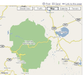
Then zoom in so the scale bar is within 1 mile or less, and the contour lines will magically appear:
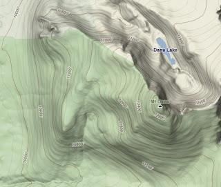
This can come in very handy for planning your next geocaching outing. Just another tool for the tool box.
Happy Cachin'!
To see it for yourself, launch Google Maps, go to your favorite area, and click the Terrain button:

Then zoom in so the scale bar is within 1 mile or less, and the contour lines will magically appear:

This can come in very handy for planning your next geocaching outing. Just another tool for the tool box.
Happy Cachin'!
March 28, 2008
Google Earth, Part Deux
In a previous post, we talked about how to view geocache locations in Google Earth before you head out on your geocaching adventure. But the fun doesn't stop there. You can also use Google Earth to see where you've been after you get back from an exciting day of geocaching.
As you probably know, while you're busy navigating from cache to cache, your GPSr is doing more than just showing you the cache locations. It's also recording your tracks. And the beauty part is that you can load these tracks (and your waypoints) into Google Earth once you return home to see the exact path you took while out hunting caches.
There are a number of programs, like GPS Utility, and/or web sites, like GPS Visualizer, that will let you download your GPS track and waypoint data, and convert it to a Google Earth (KML) format. You can also import native GPSr file format (GPX) data directly into Google Earth.
As you probably know, while you're busy navigating from cache to cache, your GPSr is doing more than just showing you the cache locations. It's also recording your tracks. And the beauty part is that you can load these tracks (and your waypoints) into Google Earth once you return home to see the exact path you took while out hunting caches.
There are a number of programs, like GPS Utility, and/or web sites, like GPS Visualizer, that will let you download your GPS track and waypoint data, and convert it to a Google Earth (KML) format. You can also import native GPSr file format (GPX) data directly into Google Earth.
Here's a sample of one of my recent bike ride/cache hunts as seen in Google Earth. You can adjust the line color and thickness to suit your needs:

You can also either download your waypoints (presumably, your cache sites) from your GPSr, or turn on the Geocaching Network KML layer we mentioned in a previous post to see all the geocaches you passed, and hopefully found, during your outing:
 Google Earth is a great tool for planning your next hunt, and viewing the results of your last one.
Happy Cachin'!

You can also either download your waypoints (presumably, your cache sites) from your GPSr, or turn on the Geocaching Network KML layer we mentioned in a previous post to see all the geocaches you passed, and hopefully found, during your outing:
 Google Earth is a great tool for planning your next hunt, and viewing the results of your last one.
Happy Cachin'!
March 23, 2008
WWFM III Is Coming
You may be familiar with the term, "Flash Mob", described by Wikipedia as, a large group of people who assemble suddenly in a public place, perform an unusual action for a brief period of time, then quickly disperse.
Well, now there are World Wide Flash Mobs (WWFM), which are coordinated geocaching events that take place simultaneously at locations across the globe and only last 15 minutes. The idea is the brainchild of the fine people who host the PodCacher web site and podcast show, Sonny and Sandy.
WWFM II was held on November 10, 2007, and over 4,300 people participated world wide. See this video for a high-energy recap of the event.
If this sounds like fun to you, then you're in luck, because WWFM III is set for May 10, 2008, at 10:00 AM! For a list of the different WWFM III events around the globe, use this geocaching.com search. I expect the list will continue to grow, so keep checking to see if there's an event planned near you.
Well, now there are World Wide Flash Mobs (WWFM), which are coordinated geocaching events that take place simultaneously at locations across the globe and only last 15 minutes. The idea is the brainchild of the fine people who host the PodCacher web site and podcast show, Sonny and Sandy.
WWFM II was held on November 10, 2007, and over 4,300 people participated world wide. See this video for a high-energy recap of the event.
If this sounds like fun to you, then you're in luck, because WWFM III is set for May 10, 2008, at 10:00 AM! For a list of the different WWFM III events around the globe, use this geocaching.com search. I expect the list will continue to grow, so keep checking to see if there's an event planned near you.
March 15, 2008
The Oldest Geocaches
Shortly after, more people began hiding these “stashes” and posting the coordinates on the internet. On
If you’d like to figure out which was the first cache hidden in your state, you can create a Pocket Query that’ll tell you. Here’s how:
- Within radius of 500 miles
- Placed During (this is the key field)
- Between
If there isn’t a cache in your home state that falls within this search criteria, try extending the end date of the query until it produces some results.
You can also modify this query to, say, find the oldest caches within a set radius of your home (using the From Origin query selection). Or, of all the caches you have found so far, find the oldest geocache hidden (check the “I have found” box). You may have to play around with the end date a bit to generate results you can use.
Keep on cachin!
Subscribe to:
Posts (Atom)