February 22, 2009

Phoning In Your Finds

Not too long ago, a new feature was added to the geocaching.com web site called, Field Notes. You can access your field notes page from your profile page by clicking on the "Access My Field Notes" link on the right hand side of the page. Here you'll see a list of four devices and programs that support logging finds, or other information, from the field: the iPhone, Trimble's Geocache Navigator, Garmin's Colorado and Oregon GPS receivers, and DeLorme's PN-40 GPS receiver.

Luckily, the Field Notes service isn't limited to just these devices; anyone with a cell phone that can send/receive text messages, and a geocaching.com premium account, can log cache information from the field (more on that in a minute).

But what exactly is "Field Notes"? Basically, Field Notes allows you to temporarily log a find or a DNF without posting a log on the cache listing page. This lets you log your find "out in the field" without posting it to the cache listing's page immediately. Later, when you get back home, just go to your Field Notes page and click the "Post Log" link. It will pre-fill the log submission form for the cache with the correct date, log type and text you entered from the field. You can add any additional details you want and then submit your log as usual.

You can also link your Field Notes submissions to your Twitter account so that every time you text a log from the field, it will also generate a Twitter message for you, like this:


So how do you get started? First, you need to sign up for a TextMarks account. This is a "free" SMS-based service (text message charges may apply depending on your phone service plan). Just follow the instructions to link your TextMarks account with your geocaching.com account. Please note that in step 6 (see link), when you enter the device identifier from the TextMarks SMS message, make sure you enter the entire number, including the two-letter prefix (mine was TM) and the "#" symbol, or it will not work. So, on the "Link Your Geocache Navigator" page, it should look something like this:
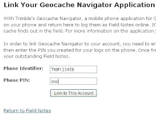

Then click on the "Link to This Account" button, and you're ready to go. If you then want to link your geocaching.com account to your Twitter account so you can send updates to Twitter when you post Field Notes via your SMS posts, you can do that here.

Once you're set up, logging a find from the field is as simple as sending a text message to 41411 with the following text: GEOC [@GC CODE] [SOME TEXT] (where GC CODE is the geocache's GC code, and SOME TEXT is any additional, optional text you want to include). Then, when you get home, go to the Access My Field Notes page on geocaching.com and you'll see a list of all the caches you've logged from the field waiting for you to either permanently log on gc.com, or delete:

This is a handy tool that can save you a lot of time logging your finds when you get back home from a day of caching. It's also nice to be able to share your caching activities with your Twitter followers live, from the field, at the same time.

Cache On!

February 15, 2009

Searching For Caches.... Online

I love pocket queries; some even more than others. There are two queries in particular that I've created, not only for downloading waypoints, but that I like to check the status of on a daily basis. These are (1) all the newly hidden geocaches within a 20 mile radius of my home, and (2) all the caches I haven't found, sorted from those closest to my home coordinates to the furthest.

Here are the pocket query selections I used to create #1 above, called "New Geocaches":

Show me 100 caches, of Any Type, of Any Container, that Is Active, From My Home Coordinates, within a Radius Of 20 Miles, placed during This Last Week:

That last search criteria selection is key, because every time you check this query, it will show you all the new caches placed within the last 7 days of the day you are checking it.

My other favorite query isn't technically a pocket query, but rather a simple search of my "Closest Unfound" caches. You can create this search in the Advanced Search section of geocaching.com. Just fill out the query boxes as shown below, replacing these coordinates with your own home coordinates, and click on "Seek".


You should now see a list of all the caches you haven't found yet, sorted from closest to furthest.

But wait; before you exit your search results page, bookmark it! Or better yet, drag a link from your address bar to your browser's toolbar. Similarly, when you run the "New Geocaches" pocket query, drag that URL link to your toolbar as well:


Now you can check these any time you want from your browser, without going to geocaching.com and then re-running a search or re-running a pocket query. And it sure beats waiting for the weekly notifications from Groundspeak to come.

Cache On!

February 7, 2009

Google Earth 5.0 Rocks!

On Monday, Google Earth version 5.0 was released, and it contains some really nice, new features. You can download it here. The new Ocean Layer is phenomenal. Not only is it incredibly data-rich, but with the added 3D bathymetry data, you can now view the terrain of the ocean floor; and even go underwater to explore it in more detail.

The new version also includes historical imagery, so you can go back in time using the time slider bar to see how different areas have changed. Google has also added a tour capture tool that lets you record your navigation through Google Earth in real-time that you can then save and play back or share with friends. And as if exploring the Earth's terrain, and now the ocean terrain, wasn't enough, they've also included Mars mode, which lets you explore Mars in 3D as well.

Check out this short video highlighting most of the new features:


While these are all great additions, there's even more great features that will definitely appeal to the geocachers out there.

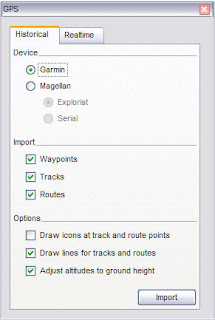
In version 5.0, you can now easily load your GPS waypoint, track and route data right from your GPS receiver. Google Earth supports over 200 different GPS models. Just connect your device to your computer, turn it on, and in G.E., open the GPS dialog box (see left) under the tools menu and watch as your data loads right into the application.

And, if you want to follow yourself in realtime on Google Earth, just connect your GPS unit to your laptop, click on the "realtime" tab (see left), and start tracking your movements.

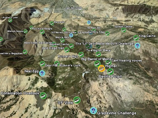
Another nice feature is the added ability to load GPX data into Google Earth simply by dragging and dropping the files right on the Google Earth screen. This is a great way to visualize your pocket queries to see cache sites that you plan to visit, or caches you've already found. It's as easy as 1, 2, 3:


1. Extract the GPX file from your pocket query download:

2. Drag and drop the GPX file onto Google Earth:

3. Choose your options:


And, Enjoy!:


You can even use the time slider bar to watch as caches appear according to the date they were placed.

Similarly, if you have GPX track data that you've saved from previous excursions, Google Earth will read and display those files too. And, if the data contains time stamps, you can use the time-slider bar to follow the progression of your tracks. There's a nice discussion of this feature in this Google Lat-Long Blog Post.

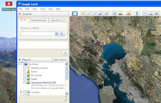
I've always been a big fan of Google Earth as a viewer of GPS track and geocaching waypoint data. And I am thrilled at how easy it is to do this now in version 5.0. So, if you've never tried loading your GPS and geocaching data into Google Earth before, now is definitely the time to give it a whirl.

Happy Caching!

February 1, 2009

Mini Map Update

In my last blog post, I talked about a cool little FireFox add-on called Mini Map. I also mentioned that it was a great application, but that the GPX file import functionality did not seem to work.

Well, this past week, I had some nice exchanges with Mini Map's application developer, and I'm happy to report that he fixed the program so you can now import GPX files; just like those that come from geocaching.com in the form of a pocket query. In fact, if you unzip a pocket query, you will notice that it contains one or two GPX formatted files, which contain all the geocache information that gets loaded onto your GPS (and PDA) device.

So for example, after unzipping my Mt. Diablo Caches pocket query, I was able to successfully load the GPX file using Mini Map's GPX import tool:

With Mini Map, you have several map background options to choose from. I used Google Maps Terrain view in the above example. You can see that Mini Map displays the cache locations from my pocket query as blue icons, and clicking on any of these brings up a call-out box with the cache information as well as a link to the cache page on geocaching.com.

It's a pretty handy little tool and very easy to use with an impressive variety of options. Give it a try if you have a chance.

Happy Caching!