July 27, 2008

Potpouri Post

For today's post, I thought I'd share a variety of "how to" information along with some recent news articles related to the geocaching and mapping world.

For Beginners Only
One of the best write-ups I've seen for people thinking about taking up this great hobby of ours, from our friends at Geocaching Online. And here's an abridged version from an earlier post of mine.

You Can Get There From Here
New on Geocaching.com, driving directions from your home location to the cache site. Just go to any cache page and click on the new “Driving Directions” link:

A Google Maps map window will open with turn by turn directions from your home coordinates to the cache site (or as close to the site as you can drive to). Pretty nifty.

Geocaching with an iPhone
If you are lucky enough to own one of the new iPhone 3G's , this article describes how to use it for geocaching. And the first geocaching application for the iPhone, Geopher Lite, is available to download for $3.99. If you're just interested in learning more about how the iPhone and the iPodTouch use WiFi signals to identify your location, here's a nice explanation. And here's how Steve Jobs explains it.

Street Cities

This site let's you embed a Google Street View and Map into your web page, and switch between map view and street view; like this:


I think there's a cache near here...

Google Maps is adding a "Walking Directions" feature. This could come in handy for tackling those urban caches in unfamiliar territory. Now, if Google would just create "Biking Directions"...


Ever wanted to create your own Google Maps map using their API, but didn't want to bother learning the API codes or javascript? Well then, let Click2Map do it for you. Just provide the location information of the features you want to map, and this site will create a map for you to post on your web site - no programming required.

BikeRouteToaster is a course creation application primarily aimed at Garmin Edge/Forerunner owners although other users without a GPS may also find it useful for planning rides. Courses are created using Google maps and then downloaded from the server.

Happy Caching!

July 19, 2008

Google Earth Image Overlays

One feature of Google Earth I like to use is the image overlay function. This works great for overlaying trail maps on top of the Google Earth background. And it's easy to do, too.

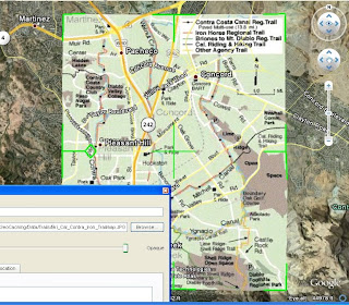
First, zoom in to the approximate area where you plan to overlay your trail map. Then click on "Add", "Image Overlay", then select the trail map you want to layer on Google Earth. Finally, drag the edges around so the map lines up correctly with the background. It helps sometimes to reduce the transparency of the image to about 50% so the background shows through. Once the image is lined up, give it a name, then click "OK", and your done.

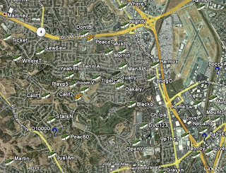
Let's take a quick run through an example. I know there are lots of caches hidden along the numerous canal trails in Contra Costa County, but when I look at the caches on Google Earth, I can't tell which caches are on the trails, and which are not.

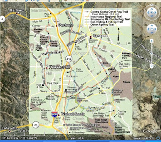
But I just happen to have a copy of the Contra Costa Canal Regional Trail map in .jpg format that I downloaded from the regional trails web site. So I add the file to Google Earth as an image overlay (Google accepts most image types) and line up the edges so it fits where it belongs.

I just name it and save it, and I'm all set. Now I've got a handy little trail map built right into Google Earth:


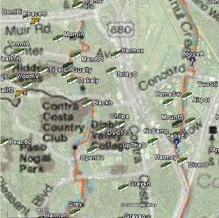
Now I can add my caches to Google Earth, and easily tell which ones I'll be hunting as I head out along the canal trails:


Cache On!

July 13, 2008

Few And Far Between

Well, it's embarrassing to admit, but until today, I hadn't found a cache in over two weeks. And it wasn't due to a string of DNF's, but rather because I just haven't been able to get out and go geocaching lately. I don't think I've had this long of a dry spell since I first started caching.

If there's a bright side to all this, it's that it sure makes you appreciate every geocaching opportunity all the more. Like today, for example. I had about a two-hour window and made the most of it by picking up some caches in Kennedy Grove Regional Recreation Area in El Sobrante, California. It's a large, beautiful park, which had long been neglected by cachers until recently, when a couple of local legends hid a series of caches, all named after members of the Kennedy clan (including Jack, Robert, Rose, Caroline, Jacqueline, Ted, etc.). The single track trails throughout the park, while a little steep, were nice and shaded by mature oak, eucalyptus and bay trees. And the views from the ridge lines of the nearby reservoir were fabulous (I just wish I had my real camera instead of my cell phone camera):


I was able to nab four caches during my all-too-brief visit to the park today, but more importantly, it just felt great to get out there again! Now, time to go log my finds.

Cache On.

July 5, 2008

GPSr Hunt

Since my recent tragedy on the trail, I've started thinking that it might be time to consider a GPSr upgrade. Not because my trusty Gramin GPS 12 unit isn't working any more (on the contrary, it's working just as beautifully as it did the day I got it), but because I've had it for nearly 10 years now and I think it's safe to say at this point that geocaching isn't just some passing fancy of mine.

While the GPS 12 has many great features, some of the newer Garmin models have some additional perks that I've always secretly wished mine had. Primarily, a color display with the ability to add background maps. So, just out of curiosity, I started looking around at different Garmin models and price ranges. And while the Colorado 400t is my ideal dream machine, it's way out of my price range.

Instead, I've narrowed my search to the GPSMAP 60CSx, the eTrex Summit HC , and the eTrex Vista HCx.


All are high-sensitivity devices with basemaps, the ability to add maps, a compass, an altimeter, and automatic routing (except the Summit). And, the Vista and 60CSx can hold up to 1,000 waypoints, compared to the 500 maximum points my GPS 12 holds.

When these units were first introduced a few years ago, their retail prices were quite a bit higher than you can find them selling for now on some of these web sites:

GPS Garage Sale (Geocaching Forums)
eBay
Froogle
Craigslist

And of course, the very slightly used models can be had for even less. So while I still haven't actually made a final decision, the more I look, the closer I get to hitting the buy (or bid) button. If any of you out there have any thoughts or suggestions on this topic, I'd love to hear them.

Cache On!