I learned a pretty nifty trick during the "Advanced GSAK" educational session given by "Hynr" at GeoWoodstock VI last weekend that I thought was worth sharing. Geocaching Swiss Army Knife, or GSAK, as you may recall is a great geocaching and waypoint data management program. It allows you to store thousands of waypoints, which you can load from your different geocaching.com Pocket Queries, and provides a powerful filtering feature which allows you to transfer just the coordinates you need at any given time onto your GPSr.
What Hynr demonstrated for those of us who attended his session was how to create a GSAK filter based on a specific polygon, which you can create in Google Earth and then import into GSAK. This can come in very handy if you only want to load waypoints within an exact area into your GPSr for an upcoming geocaching trip.
For example, let's say you plan to meet a group of friends for a day of caching on Mt. Diablo, and you only need to load all the caches that exist within the State Park's boundaries into your GPSr. First, run a pocket query that captures, at minimum, all the caches in the park and beyond. You can do this by picking a cache in the Park as your waypoint origin. SF View (GCXZ31) would be a good choice:
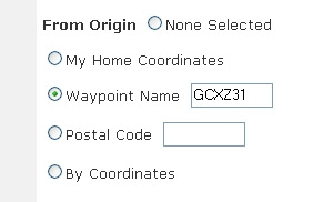
When the pocket query arrives, load it into GSAK. Next, use the "Add Polygon" tool in Google Earth to draw a polygon around Mt. Diablo by using the park boundary lines as a guide:
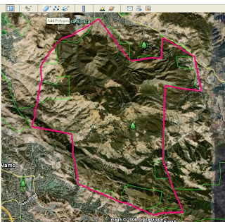
Now, save your newly created polygon as a .KML file to your hard drive. You will use this to create your filter in GSAK. Open your GSAK database, then select "Search" and "Set Filter." Click on the "Arc/Poly" tab and select the "Polygon" Filter Type. Now click on the "Select File" button and choose the Mt. Diablo polygon .KML file you just saved from Google Earth. GSAK will now automatically populate the Arc/Polygon points screen with the park boundary segment latitude and longitude coordinates from your Google Earth polygon file:
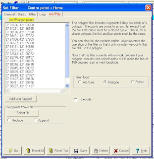
Now just save the filter and then click the Go button, and you're done. You will now have a list of just the geocaches located within the boundaries of your defined polygon ready to load onto your GPS. What's real nice is that you can create similar filters for other areas that you visit often. And, once you've created these filters, as long you save them, you can re-use them over and over for future trips to the same area.
Give it a try. I think you'll find this to be a handy little time saver.
May 31, 2008
May 25, 2008
GeoWoodstock VI - A Smashing Success
While the rain threatened all day, it never materialized. It would have taken a lot more than a little rain, however, to dampen the spirits of the 2,000-plus enthusiastic Geocachers in attendance at this year's GeoWoodstock VI in Wheatland, CA. There was so much to see and do, I can't possibly describe it all here. So instead, here's a brief summary, in pictures:
In addition, the live entertainment was excellent, the food was superb, the games and kid's activities were perfect, the educational sessions were spot on, and most of all, the people were wonderful. I am convinced that geocachers are the friendliest people around.
One final shout out to the nice and talented young lady who decorated this ammo can. This was my favorite of the bunch, so I just had to buy it.
Many thanks to the GeoWoodstock Committee Members for putting together such a marvelous event. It may be over for this year, but the memories will live on forever...
May 18, 2008
Caches Along A Route
One real nice feature available on Geocaching.com is the ability to create a pocket query of caches along a specified route. You can use Google Earth's Search/Directions feature to set up your route, and then upload that route to geocaching.com. The entire process is described on the "Caches along a Route" section on the "My Account" page.
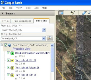
It's fairly straight forward, but let's run through a quick example. Let's say you plan on driving from San Francisco to Wheatland next weekend for GeoWoodstock VI. First, enter the information in the search box in Google Earth:
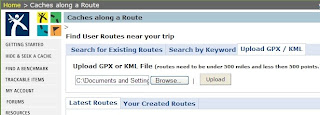
Then, right-click on the top layer of your search results (here, it's "San Francisco, CA to Wheatland, CA") and save the file in KML format to your hard drive. Now go back to the Caches Along a Route page in geocaching.com and click on the "Upload GPX/KML" tab. Click on "Browse" to select the KML file you just saved, and then click "Upload":
On the next screen that appears, select "Preview" to make sure everything looks O.K. Then, check the box next to the search title (you can change the name if you like), and click the "Save Selected" button. Now select the "Your Created Routes" tab, and you should see your new creation at the bottom of the list:
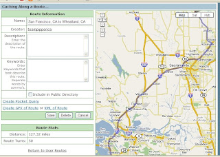
If you want to inspect the results one more time before creating a pocket query, click on the link to the left and you'll see a page with the route information and a map:
If all looks good, then go ahead and click on "Create Pocket Query", then select the buffer along the route to include in your cache search (for this route, a 0.5 mile buffer yielded over 500 caches).
And that's all there is to it. Now you've a got a pocket query containing all the cache hides between you and GeoWoodstock VI, which should make for a nice trip to Wheatland, CA.
Cache On!
May 10, 2008
My 15 Minutes of Fun
I hope some of you had a chance to experience the World Wide Flash Mob III event that took place all over the world between 10:00 and 10:15 (Pacific Standard Time) today. I understand events were planned in 15 different countries, 45 different U.S. States, and 11 Canadian Provinces.
I attended one held in Santa Rosa, CA called WWFM 08 - Hands Around The Hands. A great (albeit short) time was had by all. At 10:00 A.M. exactly, a couple dozen people converged on, and formed a circle around, the hand sculpture in the plaza:
Then, at exactly 10:04, we marched single file (in a somewhat dysfunctional conga line) a short distance to waypoint #2. There, we traded travel bugs and geocoins. We were all given 35mm film cannisters containing our meals (Hershey's kisses). Then, we each signed a raffle ticket, which constituted our log signing. Next came the raffle drawing, where several lucky geocachers won some nice GeoCoins, including the brand spanking new WWFM III GeoCoin:
At 10:14, we all put our GPSr's up to our ears and said, "Sorry, wrong number":
And, before we knew it, it was over as quickly as it began, and everyone was gone. Many thanks to Mr. Moo and Moozer for organizing such a fun-filled event. Can't wait for WWFM IV!
May 3, 2008
More Picture GeoTagging
Just when I get comfortable using GPicSync to synchronize my digital images with my GPS tracks, I find a new tool that I think I like even better. This one's called GeoSetter, and while GPicSync has most of the same functionality, I really like the user interface of GeoSetter. Not only does GeoSetter do a great job of automating the synchronization process, it also has a lot of nice features for viewing and editing your images and GPS data.
The main screen of the program shows your existing GPS tracks and geotagged photos on an embedded Google Maps display:
You can also use the Google Maps interface to geotag other photos rather than synchronizing them with your GPS tracks.
Some of the other features I like include:
Cache On!
The main screen of the program shows your existing GPS tracks and geotagged photos on an embedded Google Maps display:
You can also use the Google Maps interface to geotag other photos rather than synchronizing them with your GPS tracks.
Some of the other features I like include:
- Automatic filling of location IPTC fields and altitude values.
- Synchronization of already geotagged images with buddy images.
- Export results to Google Earth.
- Display of the track and position markers in a Google Maps view.
- The ability to edit the photo’s header data.
- Undo/Redo capability.
- Eight different languages.
- GeoSetter’s geotagging is recognized by Picasa.
- And, best of all... It's Free!
Cache On!
Subscribe to:
Posts (Atom)