December 27, 2008

Thank You, Santa!

Was Santa good to you this year? He was very good to me, that's for sure. The only thing I specifically asked for was the Garmin Topo U.S. 24K West - California and Nevada - Micro SD Card
for my GPS receiver; and Santa delivered. But Santa was also kind enough to get me some other geocaching-related items that I didn't even tell him I wanted.

For instance, I also scored a fabulous LED headlamp. I've never been a big fan of night-caching, but I tried it last night with my new headlamp, and man did that thing light up the trail. This should also come in handy for those early morning bike rides this time of year.

Santa even found time to have his elves manufacture a GPS screen protector kit for me. Man, I must have been a good boy this year.

And on top of that, all my friends and relatives seemed to get me REI gift cards this year. I guess the word is out - I'm a geocachaholic.

So, were you all good boys and girls this year too? What cool geocaching gear did you find under your tree? Please share your favorites in the comment section below.

Thanks, and happy caching!

December 20, 2008

Changing User Names

So I've been geocaching for a few years now (5 years and 2 months, to be exact), and I fear my geocaching.com user name is in need of an overhaul. For one thing, "Teampipperice" just has way too many characters in it. So many, that it takes up an entire nano cache log sheet.

Not only that, but the moniker is just nonsense to anyone outside of my family. See, I started geocaching about the same time we got our dog, and my children could not agree on what to name her. One wanted Pippi, and the other wanted Licoricise, thus, Pipperice was born. So be warned, this is what happens when you let your kids come up with names for pets and geocaching id's. By the way, you can see Pipperice in one of the photos in the upper right corner of this blog.

So I recently began my quest for a new user name. I started by searching the Groundspeak forums and found this post on the subject. The first thing you have to do is make sure the user name you want is not, nor has ever been, registered. You can do that with this lookup tool. Of course, my first choice for a new user name was "GeoJoe", but that name was taken long ago, as was every possible related version of it:

GeoJoeMama??? So, it looks like this is going to be trickier than I thought. Time to expand my search radius. I've always been partial to the name Moe, or anything with "Mojo" in it. But alas, every possible iteration and combination of these names are already taken as well, including MoeJoe, MoJo, Geomojo, Mojojo, and even GeoHobo. It appears, however, that "geohobojoe" might be available, but then again, that defeats the whole purpose of coming up with a shorter user name. Oh well, maybe I'll just hang on to Teampipperice for a while longer.

I hope you all are happy with your geocaching user names and won't ever have to worry about changing them.

Cache On!

December 12, 2008

Geolocate Your Blog Posts

For those of you geocaching bloggers that use Google's Blogging application, Blogger, did you know there is a draft version available for your use as well? It's called Blogger in Draft, and includes certain "beta" features that have not yet been added to the regular version. A recent addition to the Blogger in Draft application that will no doubt be of particular interest to us cachers is the ability to geolocate your blog posts using the new 'add a location' button!
Clicking the button opens a small Google Map. To enter a location it is possible to just click on your location on the map or use a search box to find your location. When the post is published, a geotag is displayed below the blog post as a link, which will open up Google Maps. The location is also included in the blog’s RSS and Atom feeds using GeoRSS.
Since today's blog post is not location-specific, I used the add location tool to link the post to the top of Mount Diablo, a local landmark. I've also geolocated last week's blog post to the North Pole (well, North Pole, Alaska) since it had a Christmas theme.

Cache (and geolocate) On!

December 6, 2008

Merry Cachemas

Not sure what to get that special geocacher on your Christmas list? Have no fear, as the fine folks at Geocaching Podcast have taken all the guess work out of that chore by providing a Geocaching Gift Guide, with items sorted by price range. You can also listen to their gift guide podcast by clicking on the "Show Audio" link, where each item is discussed in more detail. I definitely plan to send this link to all my friends and relatives.

The only item I would add to their list would be Garmin's 1:24,000 TOPO Maps. They cover various regions of the U.S. and I understand have routing capabilities as well. The files come loaded on mini SD cards, so they can only be used on compatible Garmin devices, such as the GPSmap 60csx. While this item retails for $99.99, I've seen it selling in the $70 range on other online reseller sites.

And if that's not enough, Groundspeak offers a slew of gift ideas for the discerning cacher. See their shopping site for all sorts of geocaching accessories, containers, clothing, and stickers. For the geocacher who has everything, how about a Signal The Frog Antenna Ball?

Here is a list of other sites that carry numerous items for the geocacher in your life:


And finally, don't forget, on Christmas eve, you can track Santa's flight on the Norad Tracks Santa web site. If you go there now, you'll see a count down till take off, plus video from last year's flight. You can also add the countdown widget to your iGoogle page and a Santa tracker for your mobile phone.

Happy Holidays and Happy Caching!

November 30, 2008

Geocaching Hodge Podge

For this week, thought I'd post links to recent posts from other sites that I've found helpful:

How to Load Maps on Garmin GPS Units
Nice, brief tutorial (with pictures) from GPS File Depot.

Batch and Reverse Geocoding
For those of you always looking for free and simple geocoding tools, here's a nice choice as described by our friends at the Free Geography Tools blog.

Downloading USGS Topo Maps in GeoPDF Format
Another great post from the Free Geography Tools blog. This is especially handy for nabbing quad challenge caches. Note: there is a new USGS link which is different than what was listed in the above post.

Norad Tracks Santa
The Santa tracking web site opens Dec. 1. Read all about it, and some interesting history, in this Google Earth Blog.

Driver Follows GPS Into Lake
Don't try this at home.

Finally, I'll leave you with a Bay Area Backroads TV segment from many years ago featuring some local geocaching icons. A bit dated, as TeamAlamo has recently eclipsed the 30,000 mark; well beyond the 4,800 finds he had way back when. Nonetheless, still fun to watch:

November 22, 2008

Holiday Geocaching

With the holidays coming up, many of us will be doing a fair amount of traveling. If you're headed out of state, this may be a good opportunity to pick up some caches in states where you haven't found any geocaches yet. Or, if you're like me, and will be doing a lot of intrastate traveling, then you no doubt will be making sure you map out a route that takes you through counties, USGS Quadrangles, and DeLorme Gazetteer pages containing un-found caches. Of course, I'm referring to some of the Challenge Caches described in a previous post here.

If you'll be driving through different counties over the holidays, you might want to utilize the services of the web site called, "It's Not About The Numbers". All you have to do is download a pocket query of your finds from geocaching.com (click on the "Add to queue" button at the bottom of the page):

Then, after you receive your pocket query file, upload it on itsnotaboutthenumbers.com. Now go to the Other Stats/Maps/US Individual State Maps with Completed Counties and check out the map showing the counties you have finds in already, and those that are still waiting for you to conquer:

Now I can see which counties we need to drive through to get to grandma's house!

There are some other tools I like to use to help me figure out which USGS Quadrangles and DeLorme pages where I'm still lacking cache finds. These applications require the use of the geocaching and waypoint management program, GSAK. Some very kind and talented people have written GSAK macros that will calculate this information for you. All the GSAK macros are available on the macro forum, free for your downloading pleasure. One of my favorites is the Challenge Cache Analyzer macro, written by hynr.

This powerful little macro can analyze your cache find data and determine which quadrangles and DeLorme pages you have, and have not, found caches. And, it can do this for just about any U.S. State that has challenge caches of these types. Not only does it report the results, but it can display the results in Google Earth:

Whoa, that's a lot of un-found DeLorme pages. Wish I had relatives in Humboldt County.

At least this Quad challenge looks a little more managable.

There are many other great macros available for GSAK users. If you don't already own a copy of GSAK, you can download a trial version and use it for 21 days. After that, if you like it, you can pay the $25 fee and it's yours. A good investment, IMHO.

Cache On and Happy Holidays!

November 15, 2008

Geocaching Meets Twitter

It was only a matter of time before the two worlds of web 2.0 social networking and the geek-leaning geocaching communities collided. Wikipedia describes social networking as, "a service that focuses on building online communities of people who share interests and activities, or who are interested in exploring the interests and activities of others. Most social network services are web based and provide a variety of ways for users to interact, such as e-mail and instant messaging services."

There are literally hundreds of social networking websites, and more coming online all the time. One of my favorites right now is Twitter, all thanks to this recent blog post by Northwoods GeoCats. Rather than repeat the same information here, I encourage you to take a minute to read that blog post, which provides an excellent introduction to the service.

The beauty of Twitter is its simplicity. You create a list of people to "follow", and others add you to their "following" list. There are a number of geocachers currently using twitter, and by adding them to your following list, you get to see what they're up to every time they post an update, or "tweet". These short text blasts are as varied as the cachers who post them:
  • found bkip's 101st hide, that's a lotta hides.
  • Downloading the rest of the valley on my PN40, 5.4gb. My 8gb card is groaning.
  • taking a 12 mile hike today!
  • final tally for the day: 3 finds, 1 DNF
  • archiving a cache because the building it was on has disappeared
You can also include links to other sites in your tweets to let other cachers know that you found a cache-related news item, or you just uploaded photos on flikr, or published a new blog post.

But beware; Twitter can be very addictive. Remember how exciting it was to get messages on your telephone answering machine (25 years ago), or to hear your computer say, "You've Got Mail" (15 years ago). Well, Twitter's kinda like that, but on steroids. If you use the TwitterFox add-on for Firefox (for which there are many), you'll find yourself constantly glancing at the bottom-right corner of your screen for new tweets:

The best way to get started on Twitter, once you've set up an account, is to just start following people. Then you can check their profiles to see who they're following, and find more people to follow. For example, if you open my profile, you'll see a list of the people I'm following on the bottom-right part of the screen:


Click on any of these icons to see if you share similar interests, and if so, add them to your following list. Before you know it, your list will grow and you'll be getting more tweets than you can handle.

Note that the Twitter "Find People" tool doesn't appear to be working at the moment. But there are other options, such as the Twitter Grader search engine. Type in a name or a term, like "geocacher" and see who pops up. Twitter Grader is also a good site to check out the profiles of the "Twitter Elite".

Another great site for newbie tweeterers is, TwiTip. In particular, this post is perfect for beginners. It's worth noting that I learned about this site in a recent "tweet" from EMC of Northridge.

Of course, not just geocachers are using Twitter. Even people like Al Gore, John Cleese, and Leo LaPorte tweet. And you can follow them too (even though they may not follow you back). And there are tons of Twitter Tools out there for the taking, including applications for your desktop, your browser, and your mobile phone and iPhone (Twitterrific is a nice one).

So go ahead and jump in. I hope to see you on Twitter soon.

Cache and Tweet On!

November 8, 2008

So What is a GPX File Anyway?

You know those Pocket Query files you get from Geocaching.com, or the files you can download directly from a cache page when you click on the "GPS eXchange File" button? Did you ever wonder what they are exactly? Well, we'll try to solve that little mystery here.

These GPS exchange files, or GPX files for short, are designed specifically for describing and transferring GPS data between software applications. They can be used to describe waypoint, tracks, and routes. Its tags store location, elevation, and time and can in this way be used to interchange data between GPS devices and software packages. Such computer programs allow you, for example, to view your track, project your track on satellite images (e.g. Google Earth), annotate maps, and tag photographs with the geolocation. The minimum properties for a GPX file are latitude and longitude for a single waypoint. All other variables are optional.

Go ahead and download a waypoint from a cache web site on Geocaching.com by clicking on the "GPS eXchange File" button:

Now open up the file in a text editor, such as Notepad. You should see various tags describing all the different aspects of the cache, including cache name, owner, date placed, type, terrain, and most importantly, latitude and longitude. Basically, the file contains all the information you would find on the cache page itself, but in a format that allows you to transfer that information to your GPS or to other software and web applications that can consume that information.

In these previous posts, we discussed some of the many things you can do with your GPX files, beyond just copying them to and from your GPS device. For example, you can open them in Google Earth for viewing waypoint locations, you can upload them to web sites such as GPS Visualizer and AnalyzeMyTrack to view your data in different ways. The possibilities are endless.

For more detailed information, see the this discussion on the Topografix web site.

Cache On!

November 1, 2008

Election Mapping

I hope all of you take time out from your busy geocaching schedules on Tuesday to vote in this year's historic election. While I'm struggling to find any solid connection between caching and voting to discuss in this post (other than ballot measures that expand access to new open space areas, which of course means more geocaching opportunities), there is definitely no shortage of mapping tools available this year to help you monitor election activity on Nov. 4th. Here are just a few examples:

  1. Historical Elections Results. See how each presidential candidate fared, state by state, in every election since 1980.
  2. Predict the Results. Use this map to see how the electoral votes of each state can make or break the election. Follow along with this map on election night.
  3. Electoral Vote. This map currently shows predicted results based on polling data, and is updated daily. Presumably, this map will reflect the actual electoral voting on election day. It's also monitoring house and senate races as well.
  4. 2008 Interactive Electoral Vote Map. Another good map to follow the election results on November 4th.
So as you can see, there are many election mapping options available to help you follow the activity on November 4th. Just don't get so wrapped up in monitoring the returns that you forget to "cache" your vote.

Cache Early and Cache Often!

October 26, 2008

Challenge Caches

The web site Cacheopedia defines a challenge cache as a puzzle cache that requires geocachers to complete certain tasks (e.g., to find other geocaches meeting certain requirements) before they can log it. Typically, geocachers must send an email to the challenge cache owner providing evidence that they have completed the challenge requirements, and the cache owner replies with the coordinates of the cache.

Chances are, if you've been geocaching for a while, you've probably already met some of the requirements for a number of the various challenge caches that are out there. For example, most states have a "Counties Challenge" cache, requiring cachers to find one cache in every county in the state before the cache owner provides them with the coordinates to the final cache. In California, this cache is known as, "Discovering and Logging California's 58 Counties".

Similarly, many states or regions also have Quad Challenge Caches and DeLorme Challenge Caches. The former requires you to find at least one cache in each USGS Quadrangle Map section in a given area (see, for example, the Bay Area Quadrangle Challenge), while the latter requires you to find one cache within the boundaries of each page of a state's DeLorme Atlas & Gazetteer (see, the Colorado DeLorme Challenge cache).

Here's a screen shot showing the 70-Quad grid from the Bay Area Quadrangle Challenge listed above:

To log this cache, the successful cacher must first find one cache in each of the map grids shown above, before the cache owner will provide him/her with the coordinates to the final cache. Other interesting challenge caches include:
Obviously, these types of caches are not likely to be found in a single day, even by the most determined of geocachers. Instead, these tend to be long-term endeavors. Thus, it's always fun to continue to monitor your finds in relation to the different challenge caches in your state and area to see how close you are to being able to request the final coordinates from the cache owner.

Cache On!

October 19, 2008

iPhone Geocaching

If you're lucky enough to own one of the new iPhone G3's (I wish), then you might be interested in some of the geocaching applications that are cropping up in the iTunes App. Store. Since the new iPhone uses a combination of GPS, Wi-Fi positioning and cell towers to determine your approximate location, it makes for an ideal Geocaching device.

Here's a brief run-down of some of the iPhone Geocaching Apps. currently available:

  • Groundspeak's Geocaching iPhone Application. Cost: $9.99. Just released this week. Boasts direct access to Geocaching.com's database of worldwide geocaches; searches by current location, address or look-up code; allows you to save geocache listings for quick retrieval; navigates to geocaches with a simulated compass arrow; and provides trackable item details. Some of the early reviews are mixed, with the majority of complaints being that the application does not allow you to log in to your account, filter your found caches, or let you log your finds and trackables. Supposedly, however, some of these features will be available in future versions of the application.
  • iGeoCacher. Cost: $14.99. Stores cache information "off-line" in an SQL database on your device, allowing for true paperless caching. Also provides seamless integration with the on-board GPS. This received many positive reviews from users, although there were some complaints about apparent set up difficulties.
  • Geofinder. Cost: $0.99. Allows you to list the geocaches closest to your current location. Reviews were not very positive. Many felt you are better off just using the Safari browser on your iPhone to access the geocaching.com web site directly, or spending an extra $1.00 for Geopher Lite.
  • Geopher Lite. Cost: $1.99. This was one of the first iPhone geocaching applications that came out and has received positive reviews. It allows you to check your current location via geocaching.com for geocaches in your area, then use the built-in directional arrow to lead you to your destination. Note that there are some on-going issues concerning the Groundspeak terms of use, which you can read more about in the Geopher blog in the link above.
  • Geocaching Toolkit iGCT. Cost: Free. Helps you solve multi-caches and puzzle caches out in the field by providing numerous waypoint calculation, text calculation, and hint decryption tools. Received very high review ratings.
  • Seek Cache. Cost: $0.99. Similar to Geofinder above. Sends your location (based on your iPhone's GPS/Wi-Fi derived location) to geocaching.com and returns a list of nearby caches. Reviews were mixed.
You can search the iTunes App Store using the key word, "Navigation" or "Geocaching" to look for updates to and reviews of the applications listed here, as well as any new geocaching tools that become available.

Enjoy, and happy iCaching!

October 11, 2008

Geocaching and Mapping (not in that order)

My humble apologies for this late post. I try never to let more than one week go by between posts, but I recently changed internet service providers and have been dealing with all sorts of issues related to the switch; including lost internet access through my gateway, network file and printer sharing problems, and a host of issues created by the anti-virus/firewall software that comes "free" with my new ISP.

Anyhow, enough about that. Let's get on with the good stuff:

  • If you own a Garmin GPS device, then you are no doubt familiar with the Garmin Communicator Plugin that allows you to transfer any cache waypoint directly from the Geocaching.com web site to your GPS unit. But did you know you can also transfer the location of the results of a Google Maps search to your device as well? In this example, I used Google Maps to locate REI stores in the East Bay area. After clicking on the marker of the one I wanted (in Berkeley), and then clicking the send option, I get the following pop-up screen prompting me to send the coordinates to my GPS (or email, phone, or even car): Pretty nifty. Read more about it on the Garmin site here.
  • Services like Picasa and Panoramio allow you to post digital images on a web-map to indicate the location where your picture was taken. Now there's a service called Woices that let's you record and post locationally-accurate audio data. So the next time you're out caching and you want to share your thoughts out loud about a particular geocache right from the cache site, you can do it here.
  • And finally, after a rough day of Geocaching (or reconfiguring your home network), you may want to treat yourself to one of your favorite India Pale Ales, or a nice glass of Sangiovese. Of course, that means trying to find the perfect place to imbibe. Well, now you can let any one of these Google Maps mash-ups take all the guess work out of that task for you.
Enjoy, and happy caching!

September 28, 2008

WWFM IV - 11/08/08, 10:00 AM (PST)

Well, the votes have been cast, and the date set for the next World Wide Flash Mob Event (#4). It is scheduled for Saturday, November 8th, at 10:00 AM (PST). As you may recall, the WWFM's are the inspiration of Sonny and Sandy, the dynamic Podcaching duo.

The basic idea behind these Flash Mob caching events are that they all start at the exact same time all around the globe, and that they only last for 15 minutes. Here's a recap of a WWFM III event I attended last May. For more information, see this fourm post.

To find the nearest WWFM IV event scheduled near you, keep an eye on this bookmark list. If you don't happen to live in the Pacific Time Zone, check here to find out the exact time the event will begin in your area.

Enjoy, and Cache On!

September 21, 2008

Build Your Own GPS Unit

From MakeMagazine, Bre Pettis teams up with Hardware Hacker Joe Grand to show you how to integrate LCDs and GPS into your electronics projects.

Watch these two self-described "smooth and efficient electronics podcasting ninjas" show you how to build your own portable GPS device, and then use it to go geocaching:


Cache On!

September 9, 2008

Biking + Caching + Sierra Foothills = Heaven

Last weekend I had the privilege and pleasure of attending a most excellent geocaching event: the MET Downhill Bike Ride: Let's Try This Again, held in a beautiful area nestled in the foothills of the Sierra Nevada mountain range in California. You can click on the first link above to see the detailed event description, but to summarize, this was simply a 20-mile downhill bike ride (4,200 feet of total descent, to be exact), with stops along the way to look for the 27 or so geocaches hidden along this stretch of the Mormon Emigrant Trail (aka, Iron Mountain Road).

And the event (which went off without a hitch thanks to the tremendous work of the hosts; Scoobert, Bahb, and Cold Springer) was a complete and total blast. If you enjoy caching by bike half as much as I do, then you would have loved this event. Here are some pictures taken along the way. More photos, and other peoples' recaps, can be found in the cache logs.

We all met at the bottom of the hill in the morning, where the event hosts were well prepared to load and carry our bikes 20 miles, and 4,000 feet, up the hill to the start of the ride:


The event log book, plus a travel bug, all in one:


At the top of the "hill", getting ready to roll:


Typical view of the Sierra foothills on the way down to the bottom:


Needless to say, a great time was had by all. I'll certainly be keeping an eye out for similar, upcoming future events.

September 7, 2008

Getting Lat/Long Coordinates From Google Earth

As you know, you can do a search in Google Maps or Google Earth using latitude and longitude coordinates. But sometimes the coordinates are just what you're looking for, so here's a quick tip on how to find them.

In Google Earth, browse over to the location for which you'd like to find the coordinates, then click on the "Add Placemark" button in the toolbar. This will automatically put a placemark in the center of the screen and open a dialogue box that shows you the coordinates for that spot. You can also move the placemark to be able to pinpoint the exact coordinates of a specific location. To do so, click and drag the placemark; you'll notice that as you drag it, the latitude/longitude coordinates automatically update.

Here's a nice little video that shows you exactly how it's done:


August 31, 2008

Speaking of GPS Tracks...

In the previous post, I talked about AnalyzeMyTracks, a nice little web application that can evaluate and display various GPS track statistics.

Well, now I've just discovered WikiLoc, another free GPS web application, but this one lets you upload and share GPS tracks. Or, as it states on the WikiLoc home page, "Show your favorite trails", "Discover new trails". That pretty much sums it up.

You can search for other peoples' GPS tracks by activity type, including hikes, bike rides, kayak rides and many others. There's even a "geocaching" category! Or, you can use the world map feature to zoom in to your local area and see all the track data that has been posted there.

It's really simple to use, and it gives you the option to view any trail in Google Earth. You can upload your track and waypoint data in just about any format, including, GPX, GDP, KML, and of course, LOC. It also lets you upload pictures to go with your track data. Here's a sample of what you see when you select the "view details" option for any given trail:

And I'm not the only one who's impressed. Apparently, Google is as well, as they just added a WikiLoc layer in Google Earth (under the Gallery folder)! Now you can see all the track data that's been uploaded to WikiLoc right in Google Earth.

Give it a try. I think you'll like it.

August 24, 2008

Analyzing GPS Track Data

In a previous post, I talked about one of my favorite web sites for converting and viewing your GPS track data, called GPS Visualizer. Now I want to introduce you to another web tool that can analyze your track data, called, conveniently enough, Analyze My Track. As stated on the home page, this nifty little tool evaluates gpx logs from your GPS device and provides the following information back:
  • reverse geocoding: track points labeled with names of nearby features;
  • maps: view your track on Google Maps;
  • stats: distance, elevation, speed and time;
  • graphs: interactive elevation/speed/distance;
In the words of my kids, "it's way cool". Here's an example of what some of the results look like, using GPS track data from a geocaching / bike ride I did just this morning:

This is the first page you see after the web application calculates various statistics from your track data.


The tool also provides you with different interactive graphs as well as some Google Maps showing certain aspects of your tracks.

Here's part of the Google Maps map it created showing my route, color-coded by elevation (using a green to red color gradient):


And here's the elevation profile it provided:

The tool also gives you a speed vs. distance graph as well. Give it a try when you get a chance.

Cache On!

August 15, 2008

Geocaching Resources

Whether you are new to geocaching or you just logged your 5,000th find, you will find that questions about geocaching may still arise from time to time. While you probably spend most of your time looking at the individual cache pages on geocaching.com, don't forget about all the tools and information resources that Groundspeak provides and continually updates:

Resource Page
Includes detailed information on "Learning the Basics", "Contributing to Our Community", "Tools and Downloads", and "Third Party Resources".

Groundspeak Knowledgebase
A great geocaching support center with a searchable knowledgebase, troubleshooter, and download tool.

Groundspeak Forums
A fantastic way to get information on a specific geocaching issue or topic from those that have "been there, done that".

The content on all of these sites is continually updated, so if you haven't checked out these resources in a while, it's time for another perusing.

Cache On!

August 9, 2008

Adding Topo Maps To Your Garmin GPS

If you're a geography data nut and a cheapskate like me, then you owe it to yourself to bookmark the Free Geography Tools blog. In an especially relevant, recent post, Leszek Pawlowicz explains how to make your own Topo maps for a Garmin GPS. Rather than copy and paste the entire post here, I suggest you click on this link to read it for yourself.

Leszek notes that Garmin is beginning to make the 1:24,000 scale US topo maps available on microSD cards, for those units that can utilize them. Unfortunately, the Garmin microSD cards sell for around $100 a pop. Luckily, Leszek goes on to describe other, cheaper options for getting the topo maps you need, with plenty of links to other GPS Topo data resources. There's also a link to a tutorial site that explains how you can make your own Garmin Topo maps.

Thanks for the great information, Leszek!

July 27, 2008

Potpouri Post

For today's post, I thought I'd share a variety of "how to" information along with some recent news articles related to the geocaching and mapping world.

For Beginners Only
One of the best write-ups I've seen for people thinking about taking up this great hobby of ours, from our friends at Geocaching Online. And here's an abridged version from an earlier post of mine.

You Can Get There From Here
New on Geocaching.com, driving directions from your home location to the cache site. Just go to any cache page and click on the new “Driving Directions” link:

A Google Maps map window will open with turn by turn directions from your home coordinates to the cache site (or as close to the site as you can drive to). Pretty nifty.

Geocaching with an iPhone
If you are lucky enough to own one of the new iPhone 3G's , this article describes how to use it for geocaching. And the first geocaching application for the iPhone, Geopher Lite, is available to download for $3.99. If you're just interested in learning more about how the iPhone and the iPodTouch use WiFi signals to identify your location, here's a nice explanation. And here's how Steve Jobs explains it.

Street Cities

This site let's you embed a Google Street View and Map into your web page, and switch between map view and street view; like this:


I think there's a cache near here...

Google Maps is adding a "Walking Directions" feature. This could come in handy for tackling those urban caches in unfamiliar territory. Now, if Google would just create "Biking Directions"...


Ever wanted to create your own Google Maps map using their API, but didn't want to bother learning the API codes or javascript? Well then, let Click2Map do it for you. Just provide the location information of the features you want to map, and this site will create a map for you to post on your web site - no programming required.

BikeRouteToaster is a course creation application primarily aimed at Garmin Edge/Forerunner owners although other users without a GPS may also find it useful for planning rides. Courses are created using Google maps and then downloaded from the server.

Happy Caching!

July 19, 2008

Google Earth Image Overlays

One feature of Google Earth I like to use is the image overlay function. This works great for overlaying trail maps on top of the Google Earth background. And it's easy to do, too.

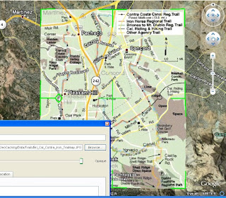
First, zoom in to the approximate area where you plan to overlay your trail map. Then click on "Add", "Image Overlay", then select the trail map you want to layer on Google Earth. Finally, drag the edges around so the map lines up correctly with the background. It helps sometimes to reduce the transparency of the image to about 50% so the background shows through. Once the image is lined up, give it a name, then click "OK", and your done.

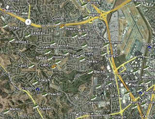
Let's take a quick run through an example. I know there are lots of caches hidden along the numerous canal trails in Contra Costa County, but when I look at the caches on Google Earth, I can't tell which caches are on the trails, and which are not.

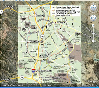
But I just happen to have a copy of the Contra Costa Canal Regional Trail map in .jpg format that I downloaded from the regional trails web site. So I add the file to Google Earth as an image overlay (Google accepts most image types) and line up the edges so it fits where it belongs.

I just name it and save it, and I'm all set. Now I've got a handy little trail map built right into Google Earth:


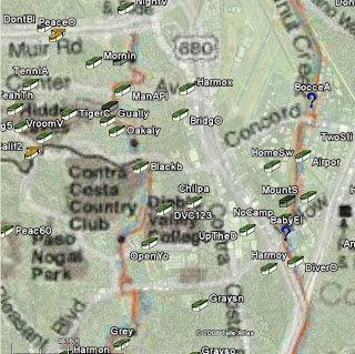
Now I can add my caches to Google Earth, and easily tell which ones I'll be hunting as I head out along the canal trails:


Cache On!

July 13, 2008

Few And Far Between

Well, it's embarrassing to admit, but until today, I hadn't found a cache in over two weeks. And it wasn't due to a string of DNF's, but rather because I just haven't been able to get out and go geocaching lately. I don't think I've had this long of a dry spell since I first started caching.

If there's a bright side to all this, it's that it sure makes you appreciate every geocaching opportunity all the more. Like today, for example. I had about a two-hour window and made the most of it by picking up some caches in Kennedy Grove Regional Recreation Area in El Sobrante, California. It's a large, beautiful park, which had long been neglected by cachers until recently, when a couple of local legends hid a series of caches, all named after members of the Kennedy clan (including Jack, Robert, Rose, Caroline, Jacqueline, Ted, etc.). The single track trails throughout the park, while a little steep, were nice and shaded by mature oak, eucalyptus and bay trees. And the views from the ridge lines of the nearby reservoir were fabulous (I just wish I had my real camera instead of my cell phone camera):


I was able to nab four caches during my all-too-brief visit to the park today, but more importantly, it just felt great to get out there again! Now, time to go log my finds.

Cache On.

July 5, 2008

GPSr Hunt

Since my recent tragedy on the trail, I've started thinking that it might be time to consider a GPSr upgrade. Not because my trusty Gramin GPS 12 unit isn't working any more (on the contrary, it's working just as beautifully as it did the day I got it), but because I've had it for nearly 10 years now and I think it's safe to say at this point that geocaching isn't just some passing fancy of mine.

While the GPS 12 has many great features, some of the newer Garmin models have some additional perks that I've always secretly wished mine had. Primarily, a color display with the ability to add background maps. So, just out of curiosity, I started looking around at different Garmin models and price ranges. And while the Colorado 400t is my ideal dream machine, it's way out of my price range.

Instead, I've narrowed my search to the GPSMAP 60CSx, the eTrex Summit HC , and the eTrex Vista HCx.


All are high-sensitivity devices with basemaps, the ability to add maps, a compass, an altimeter, and automatic routing (except the Summit). And, the Vista and 60CSx can hold up to 1,000 waypoints, compared to the 500 maximum points my GPS 12 holds.

When these units were first introduced a few years ago, their retail prices were quite a bit higher than you can find them selling for now on some of these web sites:

GPS Garage Sale (Geocaching Forums)
eBay
Froogle
Craigslist

And of course, the very slightly used models can be had for even less. So while I still haven't actually made a final decision, the more I look, the closer I get to hitting the buy (or bid) button. If any of you out there have any thoughts or suggestions on this topic, I'd love to hear them.

Cache On!

June 28, 2008

Productivity Drop

I've got a productivity problem. Ever since I started geocaching nearly 5 years ago, my total finds each year have been higher than each previous year. But as we approach the mid-point of 2008, I'm embarrassed to report that my monthly find totals so far are less than they were in 2007, on average. I'm currently on pace to find 20 fewer caches this year than last, and that's just not acceptable.

I think part of the problem is that up until several months ago, my work schedule was such that I had every other Friday off; and as it turned out, I did most of my geocaching on Fridays:


I no longer enjoy such a cache-friendly work schedule, and unfortunately, I still spend most of my Saturdays and Sundays tending to my never-ending honey-do list. So something's gotta give, because somewhere between work, home and geocaching, my priorities have gotten out of whack. On the bright side, I've still got 6 months to rectify this situation.

If you are interested in checking your own caching statistics, visit "It'sNotAboutTheNumbers" and see this earlier post about it. If you use GSAK, you can also generate your stats with this handy little macro (which I used to create pie chart above).

Now I've got to go have a little chat with my boss and my wife. Cache On!

June 21, 2008

Tragedy on the Trail

It was like a scene from an old war movie. Two soldiers, best friends who had been through countless adventures and challenges together, lying injured on the trail next to each other. One in much worse shape than the other. Realizing his friend may not make it back alive, his mind begins replaying all the great times they've had together over the years...
I guess it was bound to happen. After nearly five years and just over 1,000 cache finds, a particularly steep trail descent got the best of us. A trail so steep, I had to walk my bike down it. Suddenly, I hit a soft patch of dirt, lost my footing, and the three of us; bike, GPSr, and I finished off the descent rolling head over heels until we hit bottom.

I stood up slowly, glad to only have a bruised back side and ego. I felt even more relieved as I picked up and inspected my bike and found no major damage. But then I saw a sight that made my heart sink. My trusty Garmin GPS 12 lay helpless and motionless on the ground. I barely recognized it, with it's inner workings exposed in the hot, noon-day sun:


Was this the end of my trusted friend and companion? Had it lead me to it's last cache? I picked it up gingerly, trying my best to minimize any possible further damage. And as I glanced at the screen, I couldn't believe my eyes. Even in it's dreadful state, it was still showing me the way to the next cache, still tracking our position, as if nothing was wrong or any different than any previous outing.

Now this little guy has been dropped, kicked, rained on, and endured it's fair share of tough situations, but never anything like this. Incredibly, I was able to hold the pieces together long enough to find 3 more caches that afternoon and then get it home, apply a little epoxy, and reattach the case. Since then, it's been working as good as the day I got it. Will it see me through my next 1,000 finds? Only time will tell...

Cache On!

June 10, 2008

Google Earth Now In Google Maps

I know I talk a lot about Google Earth and Google Maps in this blog (maybe a little too much), but I find both applications very convenient and powerful for viewing cache sites before I head out on a cache hunt, as well as afterwards for viewing my GPSr tracks and cache finds. If you like Google Earth's ability to view terrain in 3D, but the convenience and accessibility of the web-based Google Maps, and wished there was a web version of Google Earth; your wait is over!

Google recently announced the release of a Google Earth Browser Plug-in, which now brings the full power of Google Earth to the web. You can download the plug-in from the Google Earth API site. Soon, you will start to see more Map "Mash-ups" that incorporate the 3D terrain effect of Google Earth. In fact, here's a fun one called Monster Milktruck that someone already put together (note: you need to install the Google Earth plug-in for it to work).

I am by no means even remotely a programmer, but I was able to throw together a simple little Google Maps mash-up with a Google Earth interface showing a few local cache sites in my web browser:


If I can do that, I can't wait to see what real programmer-types start to come up with. Here's a few early creations to wet your whistle:

Every Trail
Geo Whiz
Map Projections
First Person Camera
Bouncing Earth

Enjoy, and Cache On!

June 3, 2008

View Your Personal Cache Data In Google Maps

While Google continues to make it easier to add your own custom data to their maps using their Google Maps API, there's an even easier way to see your cache data in Google Maps without writing a single line of code. All you need is some on-line storage space (which you probably already have through your Internet Service Provider or web-mail account) to store a single Google Earth KML file.

The first thing you need to do is decide which caches you want to view in Google Maps, and then convert that list of caches into a KML file. We've talked about the versatility of the geocaching database program, GSAK before. Well, it also allows you to export your cache data into KML format. Then, just copy that file to your a web site, and then enter the http address of that site, with the .kml file name at the end, into the Google Maps search box, and presto, your caches appear on the map.

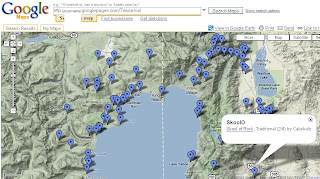
Let's take an example. Say you want to see all the caches, in map form, available in my favorite summer vacation spot, Lake Tahoe. First, import your previously defined Lake Tahoe pocket query from Geocaching.com into GSAK. Then, still using GSAK, export the Tahoe cache list to a Google Earth file that we'll call Tahoe.kml. Now, upload that file to an online server storage site, such as Google Page Creator, which provides free web storage space to Google account holders. Finally, just open Google Maps and in the search box, enter the http address of the kml file you just uploaded (in my case it's http://username.googlepages.com/Tahoe.kml:

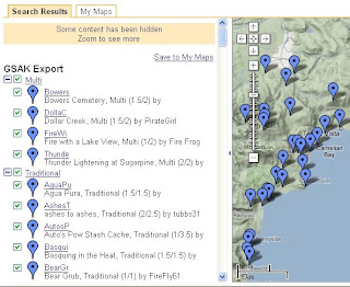
That's it! Very cool. Also, if you keep the left pane open, you'll see a list of all your caches sorted by cache type. You can click on any link, and the map will scroll to that cache and provide a pop-up box with the cache information:

This is great stuff, and nice because you can view your stored caches on any computer/laptop with internet access and a web browser. Give it a try - it's well worth the minimal effort that it takes to set up.

Cache On!

May 31, 2008

Polygon Filters in GSAK

I learned a pretty nifty trick during the "Advanced GSAK" educational session given by "Hynr" at GeoWoodstock VI last weekend that I thought was worth sharing. Geocaching Swiss Army Knife, or GSAK, as you may recall is a great geocaching and waypoint data management program. It allows you to store thousands of waypoints, which you can load from your different geocaching.com Pocket Queries, and provides a powerful filtering feature which allows you to transfer just the coordinates you need at any given time onto your GPSr.

What Hynr demonstrated for those of us who attended his session was how to create a GSAK filter based on a specific polygon, which you can create in Google Earth and then import into GSAK. This can come in very handy if you only want to load waypoints within an exact area into your GPSr for an upcoming geocaching trip.

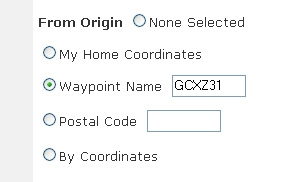
For example, let's say you plan to meet a group of friends for a day of caching on Mt. Diablo, and you only need to load all the caches that exist within the State Park's boundaries into your GPSr. First, run a pocket query that captures, at minimum, all the caches in the park and beyond. You can do this by picking a cache in the Park as your waypoint origin. SF View (GCXZ31) would be a good choice:

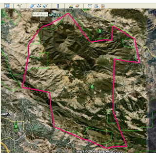
When the pocket query arrives, load it into GSAK. Next, use the "Add Polygon" tool in Google Earth to draw a polygon around Mt. Diablo by using the park boundary lines as a guide:


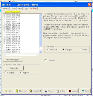
Now, save your newly created polygon as a .KML file to your hard drive. You will use this to create your filter in GSAK. Open your GSAK database, then select "Search" and "Set Filter." Click on the "Arc/Poly" tab and select the "Polygon" Filter Type. Now click on the "Select File" button and choose the Mt. Diablo polygon .KML file you just saved from Google Earth. GSAK will now automatically populate the Arc/Polygon points screen with the park boundary segment latitude and longitude coordinates from your Google Earth polygon file:

Now just save the filter and then click the Go button, and you're done. You will now have a list of just the geocaches located within the boundaries of your defined polygon ready to load onto your GPS. What's real nice is that you can create similar filters for other areas that you visit often. And, once you've created these filters, as long you save them, you can re-use them over and over for future trips to the same area.

Give it a try. I think you'll find this to be a handy little time saver.

May 25, 2008

GeoWoodstock VI - A Smashing Success

While the rain threatened all day, it never materialized. It would have taken a lot more than a little rain, however, to dampen the spirits of the 2,000-plus enthusiastic Geocachers in attendance at this year's GeoWoodstock VI in Wheatland, CA. There was so much to see and do, I can't possibly describe it all here. So instead, here's a brief summary, in pictures:

We're Here!

The Love (travel) Bug


Only in Wheatland


The cache container packing contest

In addition, the live entertainment was excellent, the food was superb, the games and kid's activities were perfect, the educational sessions were spot on, and most of all, the people were wonderful. I am convinced that geocachers are the friendliest people around.

One final shout out to the nice and talented young lady who decorated this ammo can. This was my favorite of the bunch, so I just had to buy it.


Many thanks to the GeoWoodstock Committee Members for putting together such a marvelous event. It may be over for this year, but the memories will live on forever...